Difference between revisions of "Mid Air Refueling"
From Scan New England Wiki
Jump to navigationJump to searchJetcrafter (talk | contribs) |
Jetcrafter (talk | contribs) |
||
| Line 6: | Line 6: | ||
There are two revisions since the last map from April 2008. | There are two revisions since the last map from April 2008. | ||
| − | 1. Removed the AR Laser North anchor pattern since it has not been heard or used since | + | * 1. Removed the AR Laser North anchor pattern since it has not been heard or used since all the A-10 Warthogs were removed from the Northeast during the last BRAC session. |
| − | all the A-10 Warthogs were removed from the Northeast during the last BRAC session. | + | * 2. Removed the last published frequencies from the AR-20 track. They have not been heard for many months. All comms on the track have been the 341.75/349.7 pair. |
| − | 2. Removed the last published frequencies from the AR-20 track. They have not been heard | ||
| − | for many months | ||
[[image:NE AR Map_Feb 2009.jpg]] | [[image:NE AR Map_Feb 2009.jpg]] | ||
Revision as of 15:48, 22 February 2009
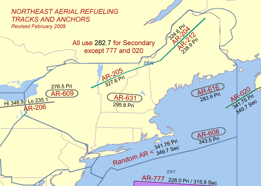
With thanks to Jetcrafter who uploaded this image to the RadioReference Maryland milcom thread. For a more detailed look at the previously undocumented AR777 area, please see the AR777 Route Maps article
UPDATE FEBRUARY 2009 - Ed Langworthy (jetcrafter):
There are two revisions since the last map from April 2008.
- 1. Removed the AR Laser North anchor pattern since it has not been heard or used since all the A-10 Warthogs were removed from the Northeast during the last BRAC session.
- 2. Removed the last published frequencies from the AR-20 track. They have not been heard for many months. All comms on the track have been the 341.75/349.7 pair.
