Difference between revisions of "Mid Air Refueling"
From Scan New England Wiki
Jump to navigationJump to search| Line 19: | Line 19: | ||
<th><b>Exit</b></th> | <th><b>Exit</b></th> | ||
<th><b>Notes</b></th> | <th><b>Notes</b></th> | ||
| + | </tr> | ||
| + | <tr> | ||
| + | <td>AR 20</td> | ||
| + | <td>341.75</td> | ||
| + | <td>269.3</td> | ||
| + | <td> </td> | ||
| + | <td>Very Active with AMC Atlantic crossers</td> | ||
</tr> | </tr> | ||
<tr> | <tr> | ||
Revision as of 19:30, 29 June 2006
Welcome to the Mid Air Refueling page. The map and frequencies presented here come from the April 2006 Area Planning 1B document (AP1B).
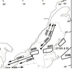

Definitions
- ARCP = Air Route Control Point: The frequency used by the ARTCC to control the location where the tanker and receiver rendezvous is completed prior to refueling. Tankers orbit at this point.
- EXIT = The frequency used by the ARTCC for control of the designated point where the tanker and aircraft may depart the anchor area after refueling is complete.
Frequencies
- The common secondary frequency for this area is 282.7
| AR Route | Primary UHF | ARCP | Exit | Notes |
|---|---|---|---|---|
| AR 20 | 341.75 | 269.3 | Very Active with AMC Atlantic crossers | |
| AR 204 NE | 324.6 | 282.2 | 319.1 | |
| AR 204 SW | 319.1 | 380.3 | ||
| AR 205 | 327.6 | 319.1 | 380.3 | |
| AR 212 NE | 238.9 | 282.2 | 346.4 | |
| AR 212 SW | 319.1 | 380.3 | ||
| AR 608 | 343.5 | 307.3 | 307.3 | Huntress 364.2 |
| AR 616A/B | 283.9 | 269.6 | 269.6 | |
| AR 631 | 295.8 | 341.7 | 341.7 | Footrope 301.6/314.2 |